
You are currently browsing the category archive for the ‘road trip’ category.
Winter road trips are not too different from summer ones. You can run into bad weather or road closures in any season. But here is my advice for long-haul driving in the winter:

1) Service your car before you leave – snow tires are essential, oil change of course, and keep a thick wool blanket in the car (in case you need to nap). It’s probably a good idea to have emergency stuff like jumper cables, fluorescent triangles, shovel and traction mats (although I don’t have the latter), but there are plenty of websites you can visit for these kinds of lists.
2) Don’t have a fixed schedule. You need to pace yourself according to road conditions and weather, and if you have a daily goal, you could stress overly or drive beyond your need to rest.
3) It’s easier to find accommodation at this time of year, so no need to book ahead. When you NEED to stop, then search for what’s available nearby (booking.com has great deals and you can book a hotel or motel in your price range immediately). Some days, I just drove through the night (45 hours straight once – I saw two sunrises!), stopping for one-hour naps (with my blanket) every now and then. When I’d had enough, I pulled into the nearest small town and had a comfortable bed at an inn within half an hour.

4) Remember daylight hours are short. I wouldn’t, however, start at the crack of dawn because it’s too cold, roads can be icy and if you’re going through a big town or city, you’ll run into morning rush hour. Best avoided. I generally start at 9:30 or 10. I don’t mind driving at night, but in British Columbia, you might want to avoid driving after dark: the sun goes down behind the mountains early and wild animals are a real hazard. So keep distances short in the Rockies.
5) You probably don’t want to drive north of Lake Superior in the winter. That’s one long, lonely, twisty, “no service” road. You can go through Michigan (Chicago, or directly south of Lake Superior through northern Michigan state), Minnesota and North Dakota. The prairies can be bitterly cold and windswept. Watch weather forecasts and stay ahead of storms, and be aware of icy roads. At some point, you will need to turn north, and it’s going to be a long and lonely and probably icy trek. Try to do it in the daylight. Drive slowly and test your brakes on the roads.
6) The worst conditions to be aware of are blowing snow or soft snow on the road that whips up with passing vehicles. This is the most dangerous. When a vehicle is about to pass or a big transport is coming towards you in these conditions, slow to a crawl or even pull over. A veil of snow in front of you can completely blind you for long enough to put you in the ditch. Don’t risk it.
 7) In bad weather and/or at night, position yourself a very safe distance behind a transport — leaving enough room to stop comfortably if the vehicle you’re following should hit an animal or stop suddenly – but close enough that the transport’s rear lights are your guiding light. These drivers travel at a steady pace and at safe speeds and they know the roads. Plus, they generally know you’re following them and will warn you of trouble ahead by flashing their lights.
8) Schedule trips over the Rocky Mountain passes for the warmest time of the day (early afternoon) when the sun is high. Check road conditions and weather forecasts. Be prepared to reroute or stop.

9) Don’t always rely on your GPS in case you lose service. Have a list of the roads you need to take or where you need to get to that day. Either copy GPS directions onto paper before you start out, or use a real map.

10) Finally, learn to recognize signs of sleepiness. Falling asleep at the wheel is a real possibility and can be deadly or at the very least extremely frightening. Long-distance driving can be mesmerizing to the point you don’t even realize how sleepy you are. Be mindful. Take frequent breaks, for gas, bathroom breaks and walkabouts. Don’t use drive-ins. Stop your car and get out. Often, a 15-minute nap is all you need to refresh and continue.

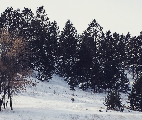
avalanche country
DECEMBER 13: THE FINAL LEG
My trip over the Kootenay Pass today is brilliant! The deep royal blueness of the sky is breathtaking and the sun glints off the white-capped mountains.

Fernie
I’ve stopped for breakfast in Fernie, a popular Alpine town near the Lizard Range of the Rockies that is completely encircled by mountains, and the drive west from there along the Crowsnest Highway No. 3 is deliciously beautiful.

Condensation rises off Elk River
Condensation rises off the frozen Elk River under the morning sun, whispering upwards in billows of white into the frosted blue landscape.
Highway 3, which I’ve picked up at Sparwood, goes all the way to the coast. I’ve travelled it many a time in all seasons. It’s a beautiful scenic route passing through some of the best parts of British Columbia and the shortest road to the sea. It’s also very windy.
My “change oil” light flickers on in Fernie, less than a week after my last oil change, but I’ll have put 5,000 kilometres on the car by the time I reach Nelson, driving day after day through all sorts of road conditions and in very cold weather.
Directly west of Fernie, there is no stopping due to avalanche risk. The mountains tower over the road on my right and a steep embankment runs down to the river on my left. Eventually, the embankment turns into a high cliff as the road climbs higher.
 The roads are compacted with hard ice and snow and slippery patches, but traffic is very light and I keep my speed down. Signs warn of ice, crosswinds, limited vision, leaping deer, and big-horn sheep – and I come across a herd of the latter on the road over the Kootenay Pass between Creston and Salmo. Between Elkford and Sparwood, I see a herd of elk and a fox.

Kootenay Pass


I’m a bit worried about the road over the Kootenay Pass, because as I approach Creston at the bottom of the pass in the early afternoon, the sky turns grey and light snow begins to fall. The mountain peaks ahead of me are draped in fog and a highway sign advises the roads are snow compacted with slippery sections. By the time I reach the peak, however – at about 1800 metres elevation – the sky has turned a brilliant azure, inviting me to take a series of photographs.
The descent is slippery and I drive at 30 kph along with a small line of traffic. Once in Salmo, I have only an hour to go to my destination of Nelson.
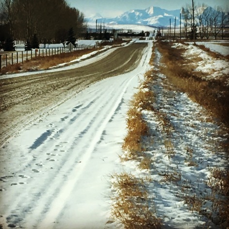
Crowsnest Pass, Alberta
DECEMBER 12: MOUNTAIN VIEW
The GPS on my phone isn’t always reliable, especially in remote areas and in the mountains. So before I hit the road each day, I quickly scribble directions in a little notepad. Old school mapping in case of interrupted technological assistance.
First sight of the Rockies
It takes me awhile to leave the city of Calgary as I fill up with gas and pick up a Starbucks breakfast. I drive south on the Deerfoot Trail and am awestruck — as always — by my first view of the mountains on my right. They sit prettily on the horizon, completely covered with snow. Eventually of course I turn west and slowly climb through them.
The north-south Cowboy Trail (Highway 22) leads to the Crowsnest Highway, a long, high, flat windswept road up to the Crowsnest Pass. Along the route, I lose my GPS directions. My phone tells me they’re not available because of road conditions, whatever that means. There’s a little bit of snow on the pass, but the weather is good and it’s sunny. Traffic is light and moving well.

The Cowboy Trail

Crowsnest Pass
The Crowsnest is a fairly low-elevation pass that crosses the Continental Divide of the Rockies. I drive by the site of the Frank Slide, a field rife with the rubble (and remains of dozens and dozens of buried residents) left when 82 million tonnes of limestone rock slid down Turtle Mountain in less than two minutes, covering part of the town of Frank, The Canadian Pacific rail line and a coal mine in the spring of 1903 when the region was still part of the Northwest Territories. A frozen piece of history.
In fact, the thriving Crowsnest community has a colourful history, complete with train robbery, shootouts and rum-running. A landmark is the 600-plus-year-old Burmis pine tree, twisted and weathered and dead for nearly 50 years, but still standing resiliently against the wind.

The Elk Valley Highway
It’s slow coming down off the pass because there are plenty of icy patches on the road. The shiny blue-grey-green rivulets running through the snow-blasted evergreens are stunning, so it’s really enjoyable to drive at a quiet pace.
I only have another hour to reach my destination: the “Wild at Heart” Rocky Mountain town of Elkford, British Columbia, which sits at an elevation of 1300 metres at the end of the Elk Valley Highway 43 near the Teck Coal Greenhills coal mining operation.
 DECEMBER 10: RETURN TO CANADA
There’s a sheriff on the scene when I pull into a station for gas and wiper fluid this morning. He’s calmly taking a report from the lady behind the counter. A car “fishtailed” out of the garage without paying.
I’m not going anywhere fast today because my car is sluggish in the minus 29 degrees Celsius weather and I’m having trouble getting my hood up to fill the windshield washer tank. A customer at another pump helps me. Thank you Mr. American.
My fingertips are so cold, my toes are numb, my car is taking forever to warm up and my phone is slow to charge.


Within a few hours of leaving Minot, North Dakota, I re-enter Canada at a little place called Portal on the Saskatchewan border. I pretty much just drive through after I’m asked how long I’ve been in the States and if I’m bringing anything in. There are no other cars.
 What I remember about the many times I’ve driven across Saskatchewan is that gas stations can be few and far between on the barren prairies. So I don’t want my gas tank level to fall below the halfway mark. The first town I come to is Estevan, where I top up with gas and pick up a couple of cups of hot water and a tea bag from Tim Horton’s.
Around four o’clock, I feel so sleepy on the flat, boring, northbound road to the Trans-Canada Highway, I stop at a little pull-in that says No Trespassing Do Not Remove Any Material. There are some very large lumps of earth. After a brief nap, my brain is foggy and I’m thinking, “Am I still on the road and falling asleep or am I actually in my car having a snooze.”

After 15 minutes, I climb out and run around the car seven times. It’s minus 21 and every time I reach the driver’s door, the harsh wind whips at my face. I climb back in, breathing hard and feeling like an ice cube. But I’m ready to hit the road again.
I make a pit stop in the city of Moose Jaw just before five. I pull into a full-serve gas station so I don’t have to freeze pumping gas, then I pick up some groceries and a coffee at a nearby Safeway.
After Swift Current, I run into bad weather. The road is partly snow-covered and huge wafts of snow drift across the road, obscuring the white lines. The road is deserted and I can barely see in front of the car. It slows me down, until I catch up to a commercial truck. I keep my distance to stay clear of the veils of snow its tires kick up, blocking all visibility in its wake. Carefully, I calculate an ideal distance between being far enough away to avoid the clouds of snow but close enough to see the red tail lights at the top and bottom of the truck. The scariest part is, two or three times a truck passes me and I drive completely blind for a few seconds. I’m seriously tense as this lonely snowy drive goes on for a good two hours all the way to Medicine Hat.
There are enormous benefits to following a commercial vehicle. It warns of problems ahead by flashing its rear lights. For example, we come across a stopped truck with little triangles all around it. Further along there’s a car moving at a snail’s pace with its hazard lights on, which is kind of creepy, and the truck warns me of that as well. With the truck leading the way, I’m able to pick up the pace to between 100 and 120 kph.
 I take another break in Medicine Hat, top up the tank again and drive down the deserted Main Street – deserted except for a magnificent deer that is wandering around.
Only a couple more hours to Calgary after Medicine Hat. Thankfully, the snow stops, the road is fine, and I arrive just before midnight.
Over the past four days, since leaving Ottawa, I’ve put four thousand kilometers on these wheels. My ears are still buzzing with road noise.

DECEMBER 9: THROUGH THE NIGHT
Through most of Wisconsin, I follow closely behind large transports to avoid hitting any animals and to save gas by travelling in their wake. They move at a nice steady pace just below the speed limit.
The driving snow eventually clears up exposing a starlit heaven, and a pale gold waxing moon falls like a misshapen stone through the night sky to sit like a lump on the horizon. The temperature falls steadily as I approach the Prairies.
By the time I hit Minnesota, I’ve gained an hour of time and the clock slips back to four a.m. Central Time. When I reach the 2,000-kilometre mark, I’ve been driving for nearly 20 hours, only snatching little naps here and there, which aren’t really naps. It’s uncomfortable in the car, because there’s too much stuff in it and the temperature outside ranges from minus five to minus 15 Celsius. I have a good winter coat and a thick wool blanket, but I get chilled quickly when I turn off the engine.

Starbucks is everywhere in America!
Just before six in the morning Central Time, I head over to the Starbucks near the Target, where I’ve been sleeping in the parking lot, and have a satisfying breakfast and change my clothes and clean up in their washroom.
I don’t really see the sun come up because I’m driving west. The shadows of the night simply dissipate slowly and the sky becomes light as if by magic. Eventually the sun does come over the horizon and blinds me in the rear view mirrors.
The further west I go, the sunnier it gets, and the colder it gets. The roads are bare. The sky is a jagged painting of clouds. The air is still. I’m getting nearer the Prairies, but I don’t have the same energy level I had the last couple of days at all.
I continue through Minnesota under a brilliant sun and on into North Dakota, gaining yet another hour as I cross the next time zone. Then I run into more snow.
The roads in North Dakota are mostly ice-packed, especially the right-hand lane, so I use the passing lane as much as possible, but as I turn north, the highway narrows to two lanes, which are covered with chunks of ridged hard ice. Big trucks heading south throw up plumes of snow that block my visibility.
The land is flat, the trees are bare and the low winter sun is blinding.
It’s minus 26 degrees when I stop to fill the gas tank at Carrington, and the station’s fuel pump malfunctions in the bitter cold. They tell me it’s at least another three hours to the Saskatchewan/Canadian border and the roads are like this all the way.
It’s not yet four in the afternoon when the sun has crossed the sky to hover on the horizon. I’ve had a lot of daylight driving as I’ve been rolling since dawn, but I’m very tired now and the last hour has been extremely uncomfortable, forcing me to stop short of the Canadian/Saskatchewan border.
 In Minot (pronounced My Knot) in the north of the state of North Dakota, I decide to look for a hotel. At the edge of town, I pull over and check booking.com on my iPhone, and settle on the Sierra Inn, which has a room available for $71 Canadian.
I have a momentary thought that I should have brought somebody with me to keep me warm between the cold hotel sheets. The bitter cold is such a shock to my system. But it’s so nice to be in a real bed after being in my car for 31 hours!
A sad consequence of sitting for so long in my car, with my heated seat on, is that I have a second-degree burn on the back of my upper thigh. When I undress in the hotel, I realize I actually have blisters and a deep hole in the skin.
I’m hoping to make it to Calgary tomorrow in 11 hours.
DECEMBER 8: CROSSING THE BORDER
For a night owl, it’s impressive that I’m on the blacktop just after 10. I’ve stayed up late the night before talking to my hosts about their travels to the North Pole last summer. Speaking of the North Pole, the temperature has dropped today to below zero and it’s crisp and wintry white. I’ve only been on the road for 20 minutes when I drive into a flurry of snow.

St. Clair River between Canada and U.S.

Bluewater Ferry
My first challenge is to cross the border into the United States. My car is loaded with “stuff” for my daughter: suitcases of bedding, curtains, books, two Ikea chairs (conveniently disassembled) and a little cube stool. So I decide to hit the rather obscure border point of Marine City, directly west of London, between Windsor and Sarnia.
I cut a jagged path across southwestern rural Ontario towards Lake St. Clair and catch the Bluewater Ferry across the St. Clair River into the States. Costs me seven bucks and takes five or six minutes. There’s a one-man booth on the other side. I’m asked a few questions and am on my way within seconds.
As I barrel through the state of Michigan towards Chicago, the eastbound lanes of Highway 14 through Ann Arbour are completely blocked. There’s a car in the ditch. There’s a tractor trailer overturned. Snow is coming fast and heavy now and visibility is decreasing. But the westbound lanes are clear, and I have the perfect trekking playlist: Gordon Lightfoot to remind me of home, Passenger’s Rolling Stone, Home (“so many winding roads, so many miles to go”) and Young as the Morning, Old as the Sea about a lone traveller, Garnet Rogers’ Night Drive, and the driving rhythm of Appalachian folksinger Colter Wall’s Sleeping on the Blacktop to keep me energized.

Chicago
By the time I reach the lower end of Lake Michigan, the snow is coming towards me horizontally, highway signs warn of slippery roads, traffic moves slowly. In Chicago, some time after seven, the snow lightens to flurries and the roads are clear.
While my goal today is to make it past Chicago, I’m so not tired, I decide to just keep on driving, on to Milwaukee, where I will turn westwards on the I94.
I hit the 1500-kilometre point of my trip around Milwaukee. I stop at a Starbucks for a shock of caffeine, but the coffee is so bitter, I throw in a piece of my emergency chocolate to make it palatable. Nevertheless, it jolts me into high functionality and I feel like I’ve just begun my journey, even though I’ve been on the road for 12 hours, eight of them in the darkness.
It’s 10:30, but I love driving at night! I’ve filled the tank, while I’m certain of finding a gas station that’s open. The snow has stopped, and it’s a crisp minus five. The roads are free of snow and the traffic is thinning out. The night’s arms seem to enfold me into a narrow world that is my tiny car space and the few hundred metres of road in my immediate vision.
After spending most of the day circumnavigating the enormous Lake Michigan, I’m really heading west now. As I continue driving through the night, I’m excited about the possibility of the unknown path ahead.
the road behind the road ahead

the road behind

the road ahead
DECEMBER 7: THE ROAD CALLS AND I’M AWAY
My winter road trip from Ottawa to B.C. is delayed a week by 1) a horrible head cold, 2) the death of my laptop, and 3) a new on-site writing assignment – I’ll need the fee to cover the cost of my computer repair as well as gas for the cross-country journey.
When I finally hit the highway, I feel a little tumbleweed of ecstasy building in the centre of my being as the road stretches out before me. As always, it is calling me. I’m aware of my smile widening uncontrollably across my face. There’s nothing like being alone in the car – just me and the Universe as I sketch myself across this little strip of asphalt winding with possibility over the planet.
The road is clear and dry and there are only scratches of snow on the shoulders. Little jagged shining holes of brilliant blue pierce the grey white clouds in the December sky like some kind of hope. The bright white winter sun gilds the edges of the clouds as it sinks quickly in the early afternoon.
To avoid the boring and dangerous Highway 401 that passes through Toronto, I choose to travel on the back roads of Ontario and pick up the Express Toll Road around the city (which will eventually cost me more than $30 — they snap a photo of your licence plate and send the bill in the mail).
I arrive at my friends’ home near London at dinner time. The “real” journey begins tomorrow.
 SOMETIMES trips are more accurately described as a series of interesting incidents. Not so much leave Point A and arrive in Point B, but rather overcome a change of plans here, come across an unexpected situation there and adapt to the new normal.
And so, when I told a friend I was planning to visit my granddaughter in Nova Scotia, she jumped at the chance to come along to check things out for her upcoming retirement in Cape Breton.
“We’ll go in my Ford,” says she. “It’s better on gas. But when I travel, we leave early.”
“All right,” say I compromisingly, “but you’ll be doing the driving if we’re leaving at eight in the morning, because I’m a night owl and I function better after noon.”
No problem. The plan is set: I’ll crawl out of bed at seven, drive my Jeep Patriot in my morning stupor to her house about 45 minutes away and transfer my suitcase over to her little car. Then I’ll catch up on missed sleep.
And so I arrive all sleepy-headed at eight on the dot (which is worth mentioning, because it’s not an easy feat for me). I’m looking forward to snoozing in the passenger seat and maybe picking up a Starbucks breakfast in a few hours when we hit Montreal.
Incident No. 1. My friend’s car is missing. There’s no point in trying to unlock the mystery here. Between her husband and her three children, there are three vehicles and whoever drives whatever as needed. This particular morning, the Ford is absent and no one seems to know who has it or where it is.
“Can we track it down? How long do you think that might take?”
Sensing uncertainty, my foggy morning brain kicks in and I suggest, “Well, we have a perfectly good car right here. Why don’t we go in my Jeep?”

our gite in Quebec
My friend confesses she is not comfortable driving a standard, but at this point I would count Incident No. 1 as solved. My friend packs her carry-on and her backpack, her tent, camping chair, bedroll, bag of outerwear, bag of shoes and hiking boots, bag of food and a cooler in the back of my Jeep. Just as well we’re taking my very large car. Seriously.
On about five hours’ sleep, I drive the entire tiring nine hours to Sainte-Luce in Quebec’s Bas-Saint-Laurent region on the northern coast of the Gaspé Peninsula, where my friend has booked a bed-and-breakfast for us.
Incident No. 2. We’ve decided to continue north on Day 2 and to cross into New Brunswick at Campbellton. My friend’s husband has recommended the route as the more scenic one and he’s right. It’s a striking landscape, reminiscent of British Columbia, without the mountainous heights. Only we miss the turn that will take us across the J.C. Van Horne Bridge that spans the Restigouche River and we’ve gone nearly an hour too far up the inlet. As we pull into the little town of Carleton-sur-mer, I gasp as I turn to my friend and say, “I have a friend who lives here. We’ve definitely gone too far!”
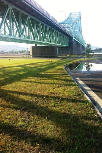
The J.C. Van Horne Bridge to New Brunswick
As we’re “here now,” I locate my friend, kind of by chance, as I haven’t been there for a good 10 years. I specifically remember the view from her door, so I’m mostly looking to my right to see if I can jog my recollection of the stony beach that faces her house.
She is not surprisingly shocked to see an old friend standing at the lip of her valley garden and plies me with uncountable kisses and hugs. It’s a wonderful moment and, with a bag of fresh pickings from her garden, we retrace our steps to the missed bridge and head south to Nova Scotia, arriving somewhere around midnight.
Incident No. 3. There is no running water at the house where my granddaughter is living. She and her mother have moved here only a few days before. It’s an old family home that has been vacant for 10 years and needs tender loving care, which it will receive over the next few years. Meanwhile, we have arrived pre-well digging project and, well, it’s not very comfortable living without running water. I share the double bed with daughter-in-law, granddaughter and dog. My friend sleeps on the floor. And the next day, we head out to “the cottage” in Cape Breton.
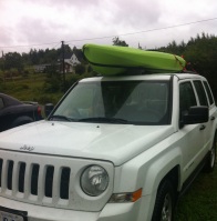
Incident No. 4. My daughter-in-law has strapped her lime green kayak onto the curved roof of her Dodge Avenger for our cottage/beach holiday, but it sways so heavily on the highway heading east to the Cape, that we pull off and decide to put the little boat on top of my jeep, which has rails and a much flatter, longer roof. A little tighter on the straps, and problem solved.
Incident No. 5. Definitely the scariest: we head off to “the cottage,” a 100-year-old house that will eventually be bulldozed to the ground, with food supplies for the several days we will stay. As we begin the “cottage opening” process, the electrical panel switch falls off, and sparks shoot out. All the electricity goes out and, as it’s late, we head to bed in the dark, leaving our salmon, steaks and chops sitting overnight in a cooler with no ice, wondering if they will be safe to eat. The next morning, a kind neighbour hooks us up with an electrician, who fixes the problem very quickly and, it turns out, our food is safe to eat.
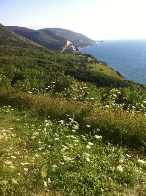
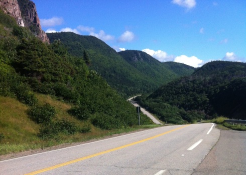
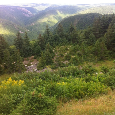
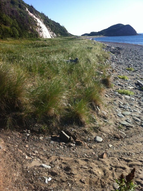
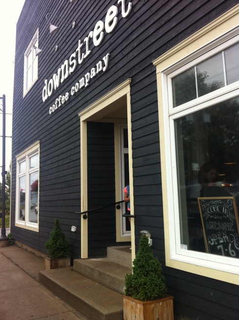
An important note here: the rest of our little summer holiday was beautiful, with a drive around the Cabot Trail, a lazy afternoon on the beach, hanging out in the quaintest of coffee shops, and some amazing barbecues.


I have to travel through the pacific/mountain date line today and will lose an hour, so I don’t want to delay. It’s a beautiful sunny day until about halfway into the trip, when a light rain begins to fall just as Simon and Garfunkel tell me I hear the drizzle of the rain, like a memory it falls . . . The soft memories carry me through the wooded mountains. I’m thinking of my loved ones as I travel alone, the ribbon of road disappearing under my wheels as I cruise eastward. My mind’s distracted and diffused, my thoughts are many miles away. As I pass the Golden Grizzly Cookhouse, just west of Banff National Park, I text my Calgary friends to tell them I’ll arrive tonight. Then I join the snake-line procession of cars crawling through the frighteningly scenic Kicking Horse Canyon. A black crow preens on a concrete bolster on the cliff side of the highway, while steel nets hang somewhat protectively from the chiselled rock faces rising out of the northside ditch. I stop briefly at the Kicking Horse Rest Area overlooking the whitewater rafting Kicking Horse River. My trip is nearly over. I’ll spend the summer settled in a Calgary suburb. But I have fallen under the spell of motion.
While I’m in the Kootenays, I hear news of a 5.5 earthquake in Quebec and Ontario. I am unable to reach my daughter in Ottawa, as I have no cell phone service in this lost valley.

Recent Comments